(Jeffreys') Ferry Butte
The first ferry at Ferry Butte near Tilden Bridge
7/14/20266 min read
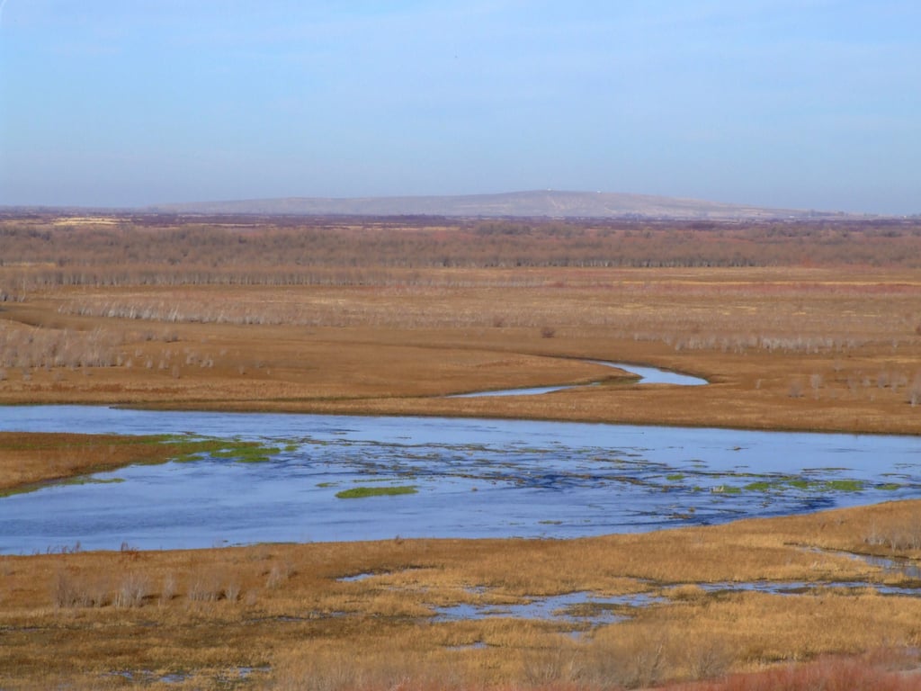
Ferry Butte in the background. Photo courtesy of Wikimedia Commons
Ferry Butte, a not-that-spectacular promontory on the Rocky Mountain scale of things (4822 at its peak, 380 feet above the surrounding terrain), was nonetheless an easy landmark for the first pioneers to spot and with which to triangulate their journeys. The nature of its position on the river also made it a good spot to put a ferry, somewhere that the river might meander less than it otherwise does during fluctuating water levels—on one side the Butte, and on the other side a rocky bluff, the river has little room to roam. Jacob Meeks and John Gibson ran a ferry there in the 1860s, but prior to their enterprise an entrepreneur—and scoundrel, by most accounts—named John Thomas Jeffreys first built a ferry there, then promoted it along with an alternative path to those going westward on the Oregon Trail.
As early as1852, emigrant wagons had crossed the eastern section of Goodale's Cutoff between Fort Hall and Camas Prairie, as a map from 1853 identifies the segment as a "new road traveled by wagon first July 20th, 1852." A decade later emigrants crossing the route found a trunk abandoned by travelers in 1853 and noticed names carved on rocks and trees dated 1854. But few took the route. Those that did were probably lured by Jeffrey's salesmanship between 1852 and 1854, when he hoped to profit from his ferry. For a time the route even bore his name, but failed because it passed through an uninviting landscape that offered limited water and grass and too much lava. Emigrants typically arrived on the Snake River Plain in the hottest, driest time of year, after having traveled almost thirteen hundred miles, so weren't too keen to take the unfamiliar route.
it wasn't until Tim Goodale's famous trip in 1862 that the trail would become well-used. Goodale led 795 men, 300 women and children, and nearly 3000 cattle in a single wagon train on the path that would be named the Goodale Cutoff. It was the largest emigrant train ever recorded on the Trail and took three hours to get underway each morning. Seventy percent of the Trail traffic would take that route for the remaining years of that emigrant pathway (the railroads wouldn't be long in coming), diverted in part by fear of native depredation on the southern side of the Snake where a well-known massacre occurred below American Falls—an event which happened the same day Goodale's massive emigrant party arrived in Boise.
Jeffreys was born in Missouri in 1830. His family made the trip west in 1845 after a many month journey and would spend some time in the California gold fields. In January 1853 John went east to Arkansas to purchase a herd of five to six hundred cattle to drive back to Oregon. He and his partner, Henry Ross, brought them back as far as Salt Lake City where they parted, Ross staying and Jeffries returning to Oregon—a $200 bounty was on their heads, both being accused of murdering the herd's owner, George Cook.
Johnny Grant, twenty-one year old son of Hudson's Bay' Fort Hall manager Richard Grant described Ross as a professional gambler who was partnered with Jeffries and lured Cook to a place where they killed him. Jeffries was described at the time of the killing as being 5 feet 9 inches high, sparely built and weighing about 180 pounds, with dark hair and the appearance of a very steady genteel man who usually dressed well.
Ross was quoted as calling Jeffreys a thief, a robber and a murderer., a man named Tibbetts adding to that appraisal: “We are all thieves, robbers and murderers, but Ross is the worst. Do not waste words with him; if you have any difficulty with him, he will shoot you; simply do not let him shoot first. I know that he and Jeffreys killed the man from whom they bought those cattle." Ross was "a dangerous and treacherous man" by another account, had reportedly shot two unarmed men prior to the Arkansas murder. He was also accused of shooting at a man four times at Soda Springs the prior summer. Jeffries and his trailmates publicly denied the allegations of Cook's murder and the Governor's $800 bounty on him, Ross, Clay Gillaspie and Charles Stevens was never claimed.
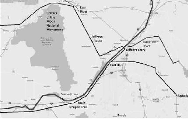
In the summer of 1854 Jeffreys returned to southeast Idaho to install his ferry and establish the alternative route to the west. He planned to charge no fee to use the new trail, instead would charge five dollars per wagon ($200, adjusted to the present) and twenty-five cents for each head of stock to ferry them across the Snake River. He built the crossing just below the mouth of the Blackfoot River, a few miles upstream from Fort Hall. The route followed ancient Indian trails northwest around the large lava area now called Craters of the Moon, then curved across the Camas Prairie before reconnecting with the main Oregon Trail southeast of the Boise River. Jeffreys claimed his route shortened the trip westward by four days.
The fall of 1854 saw Ross and Jeffreys reunited, but their partnership ended tragically when Jeffreys shot Ross near the Blackfoot Butte (now Ferry Butte). Neil McArthur, the new manager at Hudson's Bay a few miles downstream, described the event in a letter to an Oregon newspaper, saying the shooting occurred ten miles above Fort Hall. Ross had returned from Soda springs to Cantonment Loring (a short-lived military base roughly a mile southwest of the Butte) and had lost some horses. On the evening of August 26 he returned from a trip for provisions at Fort Hall in an excited state and after waiting some time asked Jeffrey to help him search for his horses. Jeffreys claimed to be sick and begged off that it was late, anyway. Ross insisted and Jeffreys consented to go as far as the ferry.
An immigrant accompanying Jeffreys gave him his shotgun in case he saw some ducks. Arriving at the ferry, Jeffrey told Ross he felt weak and exhausted, and could go no further than the top of the Butte. There they could spot any horses in the bottoms. Once at the top, Jeffrey got off his horse to tighten his saddle's girth. When ready to remount, Ross asked if he would go up to the ford of Snake River, 15 miles upstream. Upon Jeffreys' refusal, Ross belligerently asked him where his (Ross’) horses were. "You know where my horses are and you have been talking about me; I am going to kill you." Ross shot at Jeffreys but the pistol misfired. His horse startled and threw him, and before he could shoot a second time Jeffrey fired with his goose-shot filled shotgun.
Jeffreys immediately gave himself up but was found innocent in self defense.
Johnny Grant, son of Hudson's Bay operator Richard Grant, saw the event differently. He claimed someone told him the Ross-Jeffreys horse hunt was a ruse, that Jeffreys' immigrant friend had put dough in Ross's 'tubes', creating the pistol misfire. Jeffreys shot him, then took his horses to Oregon where he probably, wrote Grant, "posed as an honest man."
It's believed Jeffreys abandoned his ferry in 1855, though he was still trying to drum up business by touting the area. He wrote to the Oregon Statesman "I am well satisfied from my own discoveries that there are good mines in the vicinity of Fort Hall, in fact I believe the Hudson Bay Company have been in possession of this information for the last two years, but have been keeping it concealed for self interest, knowing that it would break up their Indian traffic." He became a lawyer and politician and was a secessionist during the Civil War—a position he claimed as the impetus for a seizure of his property. Jeffreys took part in a Confederate plot to purchase a British steamer to interfere with Federal trade near Victoria. He became a cattle buyer before dying of tuberculosis in 1867. He has only recently began to receive credit for establishing the route known as the Goodale Cutoff.
In the map attached, created by Jerry Eichorst (whose article much of this information is derived from), you can see how some emigrants may have sought to evade the 'jag' created by going north from Fort Hall to the Ferry and back south again. In low water, the Snake could be crossed roughly at the end of what is now the McTucker Creek area, saving a pioneer party about ten miles—a half to whole day.
sources:
https://npshistory.com/publications/crmo/hcs/chap5.htm
https://idahoocta.org/images/pdfs/Overland-Journal-Winter-2018-2019-John-Thomas-Jeffreys.pdf