Powell, Sweet Sage, and McCollum: The Little Lost Boom Towns that Weren't
The travails of settlers in the Snake River Plain
5/18/202613 min read

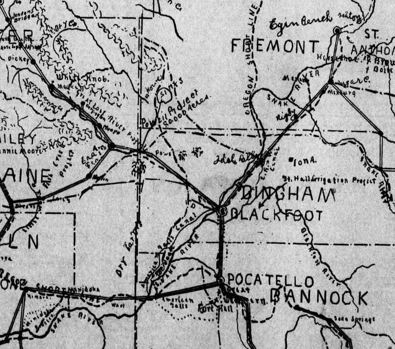
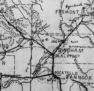
Flip the map counter-clockwise 90 degrees to get a more normal view from this 1910 map.
In the early part of the nineteenth century, few Idaho settlers faced as much oscillation between empowering hope and failed promises as those in the Howe to Cerro Grande (roughly where Atomic City now is) did. The boosterism of the time, capitalizing on the success of earlier private and Carey Act projects that, piece by piece, carved irrigable land from the Snake River westward into the desert plain from 1880 on, had its eye on the unfarmed frontier on that vast desert area—a massive tract of more than a million acres in the minds of 1890s promoters that would be trimmed by later entrepreneurs of the 1910s to a third of that. Some of the smaller projects on the Little Lost and Big Lost Rivers eventually, after considerable failures, came to fruition, while the biggest of them all, the Dubois Project running from Ashton to Howe to American Falls, got only as far as the United States Congress in 1919, never getting past the surveying stage.
A second fuel for promoters' dreams (and scams) was the expansion of the railroads, the Blackfoot to Mackay line built in 1901 still fresh in settlers' memories and the more recent Blackfoot to Aberdeen Branch, finished in 1909, just asking for the next project. It appeared as an ambitious line from American Falls to Cerro Grande northward past the Sinks, where it would eventually hook up to the railroads beyond Salmon and further on to Lewiston, connecting the West Coast to the East with yet one more set of tracks.
Dreamers imagined new railroads and canals running through the great desert between Blackfoot, Idaho Falls and Arco. In a matter of years, in their minds, thousands of new farms would turn the sere area into bountiful cropland. Blackfoot's Idaho Republican editor, Byrd Trego, fuelled the notion of wealth by bundling the explosion of towns along the Aberdeen Branch rails—Rochelle, Sterling, Springfield, Rockford and Pingree (the crowning glory of the quintet, in 1910 soon to be a 'twin to Blackfoot in commercial and agricultural importance')—with a similar process surely to soon be repeated along the proposed northward railroad trek through the Lost River country. There, a series of towns would be built: Powell (its foundations still visible on the lands of the INL), McCollum (later to be renamed Hawley, after the governor, in a last-ditch effort to get enough clout to push development into reality), and Sweet Sage. Despite Trego's and others' optimism, those dreams never came to be.
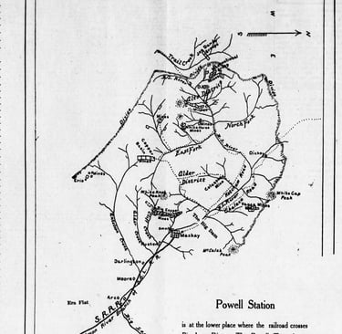
Powell Station (see map above), after 1916 called Pioneer, was being set up in August 1909 as a temporary 'white city' of eight tents, which were erected while the eighty acre townsite was being platted. A.S. Hall and associates were performing that work, and Hall said Mssrs. Horne and Lowell, from Puyallup, Washington like himself, were going to open a bank there. Hall and his associates had exclusive rights to the land when the second auction for the huge Powell Tract came up soon, and Hall was pretty sure the Northwestern Railroad was going to cross the Mackay Branch within a few hundred feet of the Powell switch.
In 1910, Hall claimed that the Powell Post Office ranked fifth in importance along the Blackfoot to Mackay Branch, sometimes doing a thousand dollars a day in freight receipts ($40,000 in today's cash), Hall sometimes cashing a thousand dollars worth of checks in a day as a convenience to the patrons. That was probably the heyday of the town, its remnants now located on the INL, viewable only to those with a security clearance.
Sweet Sage, another touted town, was located near the Sinks, below Howe. Mabel and A.L. Gilmore opened a store there in 1911, suffering through travails with the failed Little Lost project of prior years which left dozens of settlers destitute.
McCollum was a town primarily existing only in promoters' speech and in the dreams of those settlers aiming to take advantage of the water promised by ongoing irrigation projects. Intended in 1909 to be the "capital of the Lost River Tract," it was located on the east side of the lower Big Lost River, twenty miles north of Cerro Grande and 35 miles East of Idaho Falls. The proposed village was named to honor a man instrumental in irrigation projects elsewhere, Robert M. McCollum, who had ties with I.B. Perrine in Twin Falls, where together they pushed the area's major irrigation endeavors toward fruition. McCollum was announced as being on the (as yet nonexistent) Lemhi and Salmon Valley Railroad, an extension of the OSL reaching from Cerro Grande to to the mineral regions of Lemhi County. Right of way for that railroad had mostly been secured, and it was expected to reach McCollum by spring of 1910. Sixty thousand acres of The Powell Tract surrounded the town, an area that a Colorado potato king, Eugene Grubb, said rivaled his Denver-Greeley district in its potential for spud production. McCollum, it was said, would soon have a new hotel, a sewer system, an electric light and power plant, sidewalks, waterworks and other city conveniences. U.S. Agriculture Secretary Wilson said he was recommending a government agricultural experiment station for the area.
The optimistic opening of McCollum was set back from spring to summer of 1910, a February story stating that the Oregon Short Line and the Big Lost Irrigation Company had only just come to an agreement. The system builder was guaranteeing water to the area by May 1, the railroad apparently adopting a wait and see attitude, given the delays in court regarding land to be submerged by the proposed reservoir.
The map above, an original from the time period and poorly done by standards you're probably accustomed to, show the proposed railroad line from American Falls northward, along the Aberdeen-Springfield Canal, crossing the Mackay Branch line near Powell and then brushing the Sinks (in Fremont County at that time) on its west side before heading to Salmon.
McCollum town lots were on sale in late June at Arco, the railroad construction contracts said to be let earlier in the month. Powell resident A.S. Hall was taking advantage of that news by building a store at the townsite to sell general merchandise. by June of 1911, the Stewarts, a couple from Tacoma, Washington, came to settle, the Mr. accustomed to city life, having conducted street cars for his livelihood, and finding a discouraging 'great silence' at McCollum. But the Mrs., who had pioneered before, 'preached the doctrine of enjoying nature' as it was found. They had 'established cordial relationships with two coyotes and several meadowlarks.'
Meanwhile, Gilmore at nearby Sweet Sage had opened a store and started a telephone company—The Farmers' and Miners' Telephone Company of Sweet Sage, having twenty shareholders with a planned capital of $100,000. The Sweet Sage phone line was being prepared to come from Powell to McCollum before trailing up Little Lost River to the summit, a distance of 100 miles. His 'town' had fifty settlers within four miles of the post office, 150-200 people in a broader area, and with its new daily mail service it took less than ten days to get a reply from a letter to Blackfoot. Gilmore had also started a stage route in 1911. It picked up travelers from Powell, on the Mackay Branch, (approximately east of where the Highway 26 rest stop now is) at 11:30 in the morning and, for a three dollar round trip charge, getting them to Sweet Sage by 5 PM.
Area promoters touted that the Sweet Sage water table was shallow—Frank Luswell's well tapping into ground water at forty-seven feet. The potential for a usable well must have been a real source of hope, given the travails of those who carried water for miles in prior years, and by May of 1915, all the land between Roberts and Sweet Sage had been filed upon and no "knockers" needed to apply—knockers being the term used for naysayers at the time. The area was mostly dry farmed, 'level as a floor and rich as a garden.'
Gilmore may have been the most persistent of all the area settlers. He was also one of the most vociferous. One of those "duped" by the Blaine County Irrigation project's promoters, their system first envisioned in 1904 and covering an area primarily just above Howe, he described its first few years in a long Idaho Statesman article. He, along with more than a hundred others, had purchased shares in the system in the fall of 1908, having been promised by C.M. Wickham that he would build a reservoir to service 12,000 acres. At that time, though the project was not yet included by the Carey Act, he told settlers they instead could file a Homestead Act claim or Desert Act claim on their desired parcels. Some of those filers later found their claims rejected, the land being as yet unsurveyed—the company, it turned out, had sold 1500 acres with this status.
Had settlers been aware of Wickham's background, they might have shied away from his exhortations of water and wealth. But he was a slick-tongued orator having a preaching background, recently as a Reverend in Payette but before that having a long, checkered history as a Midwest revivalist preacher. He was run out of the Plains states before coming to Idaho, dismissed for behavior unbecoming a minister—hugging, kissing, and reportedly cohabitating with a twenty-four year old female parishioner. Wickham was acquitted of those charges in a public church trial that left his former throng angrily split between his supporters and detractors.
His unsavory past extended back even further. He was charged with fraud for doctoring land papers in 1889 when he worked as an attorney in Lyons, Kansas. As an Immigration Agent of the Bruneau Land and Irrigation project, he was sued for fraud by three Kansas investors. His resume, had it been available, might have dissuaded some entrymen from becoming involved in his Little Lost project.
Twenty-five families moved in by the spring of 1909, to an area thirty miles from the railroad, four to seven from a post office, and ten to twenty from timber. There being no well on the entire project, settlers hauled water in barrels and tanks a distance of one to seven miles. Not a single tree stood on the land and there was no grass. Seven years later, Gilmore wrote, all the fruit tree on fourteen thousand acres would fit "in a one horse wagon."
1909's summer was a dry one, the reservoir draining early, but Wickham continued to preach hope, telling the settlers no "new reservoir...holds up the first year." The settlers kept coming and Wickham was able to unload the project on M.H. Woods and J.S. Parks of Kansas City, a trade which Gilmore considered an unsuitable switch from bad to worse.
The 1909-1910 winter reached forty below, with extended periods of twenty-five below nights and extensive winds that prevented the settlers from hauling wood and froze solid everything in their tents. A group banded together to visit the governor with their concerns and were met with his assurance that the project would be up and running the coming year. Woods gave his likewise hopeful promise in writing in February, stating there would be plenty of water the following summer.
But there were no ditches made in the spring, no water when the first of May rolled around. On the first of June, water did reach the lower end of the project, but hadn't yet gotten to all land parcels. The reservoir itself had gone dry in a single week. By the fourth of July, there was no water at all. Some had managed to water crops once, but hundreds of acres never saw moisture. All the crops were ruined.
That fall, all the men and many of the women left the area to secure work elsewhere, and though Woods had promised aforehand that they would be compensated for crops if no water was provided, no such recompense was ever made. Hence, the settlers brought suit against Woods and his new partner Parks.
September 1, 1910 marked the drawing for the Carey Act lands, a curious event for those who already filed on land with Blaine County Irrigation Company, particularly those who had been working unsurveyed ground. Woods had apparently secured their signatures on blank application forms earlier in the year, then handed those forms to a U.S. commissioner who inserted "Carey Act" and signed that the applicants appeared on drawing day, though they hadn't. The surveyor who arrived in the territory the next year, once he heard what had happened, realized that fraud had occurred and reported it to his superiors who sent an investigator. Unfortunately, the arriving agent spoke with the offending commissioner, not the settlers, and reported that back that all was in order.
The water misery continued. By the fall of 1910 some ditches had been made, but the reservoir had gone dry in a week, water only finding a third of the promised acreage. The only harvestable crops grew by using river, not reservoir, water.No system work was done in 1911, and the following year reservoir water only lasted a few days. And in 1913 there was no water at all.
In McCollum in 1911, Nebraskans, Texans, and sheepman Henry Shaw joined the Stewarts from Washington and things seemed to be looking up, but in August the railroad surveyors were called and told to abort their work immediately. Six months later, the town changed its name to Hawley, hoping no doubt to flatter the governor enough to push work on both the railroad and canal systems. October 1913 reports said Howe area mines were generating enough ore to fill forty six-horse outfits, suggesting the importance of the railroad, but no one, apparently, was listening. A million pounds a week, eighteen to twenty train carloads, were being moved to Arco with horse-drawn equipment.T he promotions fell silent. A.S. Hall, the postmaster, reported there was nothing to do in the office. In fact, the office '(was) not yet built.'
But wait! February 1914 brought the awaited big announcement: the Short Line was ready to build, the work to begin once spring broke.
But again, wait...that promise, like so many earlier ones, went unfulfilled.
The Little Lost and Big Lost irrigation projects, seemingly potentials within reach for incoming settlers, may have primary to the optimism imbedded in the community psyche, but two bigger schemes were a driving impetus, too. The railroad north through Salmon, of course, but also a massive irrigation works called the Dubois Project. It had first seemed imminent more than a decade prior when over a million acres were set aside for its construction but, like many projects at the time, its promise faded away. But by 1909 it was being revived, in a smaller envisioning, just as the new towns of Sweet Sage and McCollum were being born.
At that time, men instrumental in creating the Twin Falls Minidoka Project—still one of the most successful of all irrigation enterprises entered in the Carey Act era—revived the Dubois venture. Pittsburgh's Kuhn brothers and J.G. White suggested a 200,000 acre system with a cost of about five million dollars (200 million by today's standards). Not long after, Charles Speerman, representing eastern investors with six million dollars promised, paid a $3200 filing fee on a 270,000 acre tract that superseded Kuhn and White's project. He proposed a 120 foot wide canal (at its bottom), eleven feet deep and forty miles long before the first lateral point was made. Engineers noted how the plain naturally sloped away from the foothills toward the river, which would make irrigation "easy." Work was supposed to begin that year—it didn't, no doubt in part due to the actions of a land register, M.I. Church, actions that included a telegram to Federal General Land Office Commissioner Fred Dennett asking him to put the Dubois project applications on hold.
The two Dubois Project proposals came in the wake of a 1907 bank run that made financing difficult, investors being skittish. But their reluctance rested more in a bureaucratic snag regarding water and land rights that the two applicants shared. It was not improved by the public scandal that brought Register Church's 'almost' criminal behavior to light. Those factors likely ended the hopes of building what might have been oneof Idaho's biggest water projects in history had it been completed.
It came to light that Church had been working both the governmental and private sides of the Dubois matter for his personal profit, but even earlier machinations interfered with the Little Lost River Project, its attorneys testifying that Church had demanded a $2500 fee should their proposal be accepted by the Land Board that Church worked for. F.A. Shaw, the project attorney, testified that he felt as if he had been 'held up'—robbed—by Church.
Thus paid, Church went on to work with those making the Dubois proposals, which covered land that the Blaine County Irrigation Company's was already designed for—presenting him with a dilemma: the smaller project had already procured his support by paying his 'commission', but the larger projects offered a bigger payout; the project lands covered the same area.
The Speerman entity paid him better:—$5000 a year for three years and $15,000 in water rights—so he advocated that the Land Board refuse Carey land segregation for the Lemhi system, though only a small portion (less than three percent) of it fell in the area covered by the Dubois projects. He felt that the carving out of even that small acreage might dissuade investors. In hindsight, the Blaine system could easily have been, with but a slight compromise, given its land without impeding the Dubois Canal, but Church had gotten greedy, taking 'commissions' from all parties—and by doing so, thwarting all of them.
The two Dubois parties were contesting rights essential for their proposals' success—Mason and Speerman had rights to the land that would comprise the Island Park Reservoir, which would be a holding area for mountain runoff to provide summer water for desert farmland, and Charles Perkins' client, the Kuhn consortium, claimed the necessary water rights that would be needed for the vast irrigation system. Church, after getting his fee from the Speerman faction, offered, for an equally significant payment, to represent Perkins client, Kuhn, and drop the 'work' he'd been providing for their opponents. Perkins balked.
Church further held up the Dubois projects by expressly coaxing the parties to compromise. Since each held a primary piece of the Dubois puzzle, he reasoned, they could work together in some way to bring the system into existence. But neither wanted to go ahead with the project in such a manner. Perkins said either we own Island Park or we don't and if we don't own it, we won't compromise. He claimed that even if Speerman had first rights to the reservoir land on paper, he had never conducted a survey, making the rights moot. His argument never came to the Land Board's discussion, so far as we know, as the Dubois Project would lie dormant until 1919.
In ethical and moral terms, almost everyone believed that Church, as a representative of the state and thus in position to sway opinion and action (even if only minimally) should not have been taking funds from any party representing Idaho irrigation projects. But Church claimed that, since he knew he was leaving his government position when he offered his services, there was no conflict of interest at all. Just 'bad timing' or 'bad optics', by today's measurements. He resigned his position but was never criminally charged for his actions.
Sweet Sage, McCollum and Powell were but memories by 1919, when a new version of the Dubois Project came forth from the Snake River Development Association and others . Itcovered 1.2 million acres that included the Taber Tract, a large area where dry farming was proving futile, despite its promising soils. The proposal made it to the Congressional House floor but encountered stiff opposition not just from Easterners tired of monetary outlays to the West but from the National Grange, Southwest agricultural interests and Midwestern farmers—all of whom felt no need for increased competition and lower prices for their products. The bill that included the Dubois Project failed.
The next year the Project joined other irrigation proposals—the American Falls Reservoir and Dam, the Yellowstone Tunnel, and the Highline Canal from Woodville to Taber—at an important government gathering to decide the area's agricultural fate. As we know, the American Falls proposal won out, though it would not come to be for another six years.