THE PEOPLES DESTITUTION CLAIM: TRUE OR FALSE
Claim records of LDS and non-LDS settlers
1/24/20269 min read
THE PEOPLES DESTITUTION CLAIM: TRUE OR FALSE
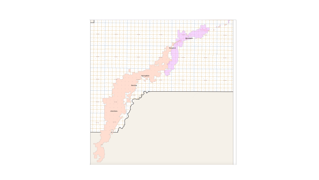
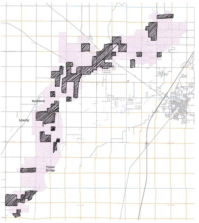
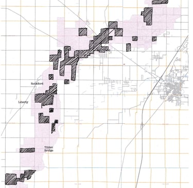
The map below shows the current areas administered by the two canals, the sections parting just east of Rockford with the Peoples border running south from there, while the Aberdeen-Springfield continues on southwesterly beyond Bingham County's south border. Each square denotes a square mile. Those areas may have slightly changed in the century since the government adjudicated which ditch covered where, but the map gives a good idea of the size of the land mass the two districts cover. The map entails the Aberdeen-Springfield's jurisdiction over 80,000 acres, though only 58,000 of that number is irrigated. The Peoples covers 21,161 acres, but reports of its irrigated area varies between 12,000 and 20,000 acres—some of its reach includes several thousand acres that its offshoot canal, the West Side (once called the Hiline), which cut through the lavas to the north, its water level fourteen feet higher than the Peoples and capable of irrigating more elevated areas located northwest of that ditch. In any case, the American Falls Canal, now Aberdeen-Springfield, is three to four times the area of its one-time competitor. Had either canal been given the entirety of the area, the sociological and religious composition of the community, one might surmise, would be far different than it is today.
In the years immediately prior to the Peoples and American Falls canals' arrivals, between three and four thousand acres in what would be a disputed area were filed upon via the Homestead or Desert Acts, with a few 'cash entry' claims—rather than filing for land, then proving up in five years, claimants could purchase land for a fixed price, usually around $1.25 an acre; such moneyed settlers were few. Allowing for a five year grace period between filing for land and proving up, those who achieved landownership by 1899, who had filed before either canal had broke ground, had captured roughly 3900 acres: 2700 acres by non-LDS claimants and 1200 by LDS. Because the Mormon Church keeps good records and LDS members often chronicle their histories, that number, taken from Church records and other historical documents, should be a fairly good estimate. There may have been, however, LDS members missed in this count, just as there might be lapsed LDS members included in the Mormon total—there were, for instance, three brothers from North Carolina who between them claimed five hundred acres nearby; they had become disaffected with the Church when the United Order in Utah interfered with their holdings there.
Among the earliest land claimants were a number of local officials or their wives. Ellen Givens, the wife of the State Asylum Director, held half a section. Charles Bunting and David Biethan, both of them supply store owners and Bunting the primary banker of eastern Idaho's entirety, held 320s, as did both Judge Ruel Rounds and his wife Annie. John Bell, a teacher and then a clerk in the state surveyor's office, had a quarter-section. Frederick Dubois, famously the generator of the anti-polygamy movement a decade earlier, had nearly half a section. These claimants were quick to the land-capture game, perhaps well-to-do enough to speculate—surely, they must have thought, the canal systems that had begun southeasterly from their land, each canal biting into the arid space a few thousand acres at a time, would eventually progress to include their unirrigated acreages to the northwest. They probably didn't need surveyors to see what ground the next canal could irrigate, and the lava beds to the north indicated there would be no further progress beyond them.
Further south along the river, Big John Watson (not to be confused with a later John Watson who was a local LDS official) filed early on a quarter section near Gold Point, mining at least part of his intentions. He ran in a rough crowd, was known as a cowboy in the Tilden (now Springfield) area and being nearly killed in a skirmish with his brother. Downstream a mile or two, LDS Joel Rich (and his father, Heber) had secured a half-section with significant water that he hoped to use in a mining operation—the dam to hold back the stream failed at least three times.
Even further downstream, the granddaddies of the area had already filed on stream-laced acreages below what is now Springfield, then Tilden, south onto the flats. Over seven thousand acres held claimants: the Johnson Brothers, renowned hellion Bilious McDaniels, polygamist Rufus Wright, and yet another Rich, Dora—her father-in-law the famed Charles Coulson, her husband Landon. Landon, according to a family account, was the first mail carrier from Blackfoot to Aberdeen. There were the Teicherts, the Wheelers, the Grovers, the Stufflebeams, most pre-1895, taking advantage of plentiful water in a place that water disputants now call 'the Reach'—the outflow of the aquifer through hundreds of streams into the Snake. Hanson Garletz's, Stufflebeams', and Hermans' Desert Claim appears on the original 1888 survey, along with those of a couple claimants who failed: A.E. Potter and a man named Wilson. There was also a 'Chicken Ranch' shown to the east of the Stufflebeam spread—that term, which later would facetiously refer to a brothel, more likely indicated the presence of a poultry enterprise, eggs going for (in today's cash) $80 a dozen in mining country in central Idaho, chickens selling for $120 apiece. Locally, of course, they were much cheaper, if marketable at all.
Justin True Grover, from Roy, Utah, and in 1892 nearly sixty years old, was among those early settlers in the 'wet' area east of what is now Sterling, on the flats. The family had a horse and ten cattle when they came, just one of those a cow and the others calves and yearlings. His family credits him with starting the first LDS Sunday School at Boone Creek for the Tilden Ward—it had seven officers and sixteen pupils. https://www.familysearch.org/en/tree/person/memories/KWNF-BTK
Grover and adjacent land owners were courted by the Peoples about the time the canal was scrambling for money—in letters to the Canal President dated about that time, the company sought landowners to put their acreages up as collateral for the Peoples to secure a loan with a Utah lender; those properties may have been the Tilden claimants', as most of those upstream had yet to gain full ownership of their land. The deal never went through.
The Peoples, like the American Falls venture, planned to eventually service the Tilden area (and another twenty-plus miles beyond)—the flats, though sometimes inundated with water on high snowpack years, still could benefit from irrigation during dry summers. Though neither canal may ever have serviced the flats, efforts would continue to bring those acreages water. The Boone Creek Irrigation Company was incorporated in 1915 to water 5000 acres of the bottomlands, its flow diverted from McTucker, Boone, and Hull creeks. Its dam on McTucker Creek failed at least three times and the company was defunct five years after its incorporation, news of the impending construction of the American Falls dam and a reservoir that would drown the flats likely ending landowner interest.
Early land patents totaling between three and five thousand acres abutted the rivers (both Portneuf and Snake) and streams of the bottomlands that extend beyond the area of the above count (which was taken from the Springfield-Sterling area), running all the way to American Falls, then just a small town. The canal builders envisioned expanding this narrow strip that settlers held, saw a ditch that would connect Blackfoot and American Falls, turning the sere desert into cropland from its banks to the bluffs of the flats and the already fertile cropland thriving there. That imagined area was sometimes no more than three miles wide, but it must have seemed significant in size when compared to the Snake River plain's aridity that went further north fifty miles.
From the proposed canal routes north of Moreland, toward the Snake in what is now the Riverside area, the LDS population had made considerable headway, but immediately southeast of the disputed area, on the Danskin Canal system, and further east under irrigation by other canals—the Parsons Ditch and Watson's Slough, for instance—a great number of early claimant acreages was held by a non-LDS population. James Danskin, who built a substantial portion of what today is his namesake canal (which abuts the Peoples' reach), had a full section of ground nearby before he died of Rocky Mountain Fever in 1889. Danskin had mining interests in central Idaho and was Sheriff there for a time. He also shipped horses to the midwest, once accompanying 500, several train car loads, to that area.
Isaac Ericson, who would buy the (likely unfinished) Danskin Canal a year after Danskin's death, had almost two sections that were watered by that canal, 500 of the 1140 acres in his wife Zada's name. Ericson was a hard working entrepreneur who would start a creamery in 1890, be one of the first to operate a steam plow, seed ten thousand acres with a "Havana' press drill and would sit on the Peoples Board of Directors before he died in 1901. Ericson performed a great deal of the excavation and construction on the Peoples canal, judging from his letters to Benjamin Cluff, and provided users at the tail end of the Peoples—many of them miners—with water late in the early years of dispute, until the Peoples finally was operating in 1899. He sold his land and was investigating an orange grove in Fresno, California, intending to move there shortly before he died. His widow would reside there, near E.T. Rose's property—the Peoples' surveyor, he had also left Idaho for further west.
The Peoples' appeal to the government rested less on legal argument than hardship—if the government ruled favorably for the American Falls canal, it claimed, hundreds of settlers, most nearly destitute, would be evicted from their land, the work they had put into their hovels and acreages gone for naught. As there was a great deal of jockeying for public perception by both canal systems, this may or may not have been hyperbole. It certainly was possible, as an LDS family might have six, eight, ten or more children, so just twenty or thirty landholding families could easily generate that high of a population number. How many of them spent the winters in the area during building is debatable, as many family accounts indicate the men returned to homes in Cache Valley when work became difficult or impossible.
Pre-canal settler population favored the non-LDS, but once word got out regarding the construction, LDS acreage—the shaded area below—more than tripled to nearly four thousand, while non-LDS land remaining almost exactly the same.
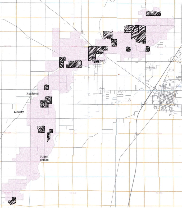
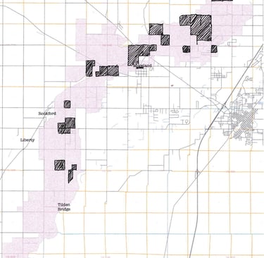
Much of the newly claimed LDS-held land, the map shows, clustered near Moreland. The shaded portions reflect LDS claims proved up on by 1901, presumed to have been filed on five years earlier—three-quarters of them after the statement pleading "destitution" was made. The area downstream, where the Peoples wasn't yet close to servicing, had very few claimants, those primarily restricted to lowlands near Rich, an area near what is now identifiable as being near Tilden Bridge and west of Ferry Butte. There were numerous Thomas filings, too.
There were ten claims made in 1897 (1902 Patent dates), four of those by non-LDS settlers, and the next year just one—doubts about the canals were rampant at that time, perhaps, as no significant water was yet flowing. But once the Peoples successfully transported water to its endpoint in 1899, the claimants flocked in: twenty-two LDS filers and just one non-LDS. The land held by Mormons in 1904 totaled 6400-plus acres, more than double that of their Gentile counterparts.
The Thomas area, southwesterly from Rockford and south of Liberty, had picked up numerous LDS claimants, and the Rich area that extended from Ferry Butte southward also saw an increase in Mormon numbers, the canal's construction at last giving confidence that water would flow.
Destitution is hard to measure. Judging from accounts, privation was normal, but it had been a theme since the LDS arrival in Utah fifty years earlier. How many of the LDS claimants were keeping a home in Cache Valley or elsewhere until their claim could be irrigated and properly worked? And how many were truly enacting their 'last chance'?
None of this can be known now, but we can see, from claimant records, that the area was not predominantly Mormon until after the legal battle between the battles ensued. Mormon population rose only after the battle cry against American Falls had begun, and didn't reach large majority proportions until the Peoples was actually flowing in 1899. It seems clear that the Peoples, in the race between the canals, was making more progress, but did its presence not deter investors from contributing to its competitor? The American Falls canal, perhaps appearing inept in is efforts, may have had its hands tied—it did not have the backing of a large religious institution, a rare sort of assuredness that the Peoples possessed and which loomed ominously, along with the Panic of 1893, over American Falls' investor confidence. The 'war' between the canals, portrayed as a David and Goliath battle between secular, outside interests and the 'native' LDS faction, may have been just the opposite: a small, independent group of individuals working through the channels the law allowed, a group fighting a much larger entity with a history of its people being persecuted—and a longer history of using that background (and embedding the storyline into a biblical drama that positioned its populace as a chosen people teleologically destined to overcome its opposition/persecutors) as a justification for aggressive actions.